Feb 23 2017
Air pollution data company now offering an interactive air pollution map on its website, allowing visitors to search for real-time air pollution levels
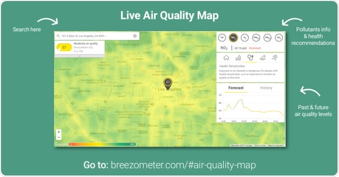
BreezoMeter, an air pollution data provider, today launches its interactive air quality map, an essential air monitor providing real time air pollution information, predictive hourly forecasts, and historical data based on its user’s address. The map, made possible by the company’s latest algorithm update, is highly visual and boasts a matchless accuracy down to the street level. Additional features include analyses of the dominant pollutants in the air, as well as health and fitness recommendations, such as when to avoid an outdoor workout or when those with health sensitivities may experience respiratory issues.

BreezoMeter is a big data platform using governmental sensors, satellites, weather patterns, transportation dynamics and other sources to analyze how pollution disperses, in a similar analogy to weather. Using concentrated traffic data, BreezoMeter has developed machine learning techniques to precisely evaluate the pollution each jam emits in real time.
“Today’s traditional air pollution monitoring methods include only annual traffic data, which doesn’t reflect the day-to-day changes residents see and breathe on their local streets,” said Emil Fisher, CTO of BreezoMeter. “BreezoMeter’s newest algorithm serves as a massive research and development breakthrough, bringing air pollution data accuracy to a new and precise level, monitored worldwide.”
“Businesses and consumers previously had to rely on inaccurate and generic point data regarding pollution, a truly global health crisis. Through a simple API, businesses can integrate this powerful data into their product, and consumers now have access to on-demand air pollution levels,” said Ran Korber, CEO of BreezoMeter.
BreezoMeter’s air quality data is currently integrated by major brands such as Dyson, Dermalogica, AccuWeather, Eureka Forbes and Cisco. The company will be showcasing its interactive map via a unique pollution dashboard at Mobile World Congress 2017 – located at Hall 5, Stand 5E81.